

-
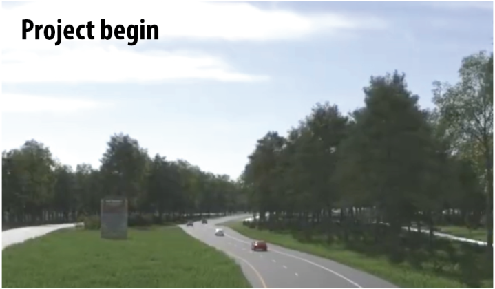 The thicket trees at beginning of project
 -
 The thicket trees at end of project
 -
 Summary of key project changes
 -
 A photo of the Big Thicket roadway as seen currently
Removing 13 miles of trees on Highway 69 (U.S. 69) just north of Beaumont in Hardin and Tyler counties will exponentially increase the flood threat to Beaumont and Hardin County, Big Thicket Natural Heritage Trust’s Ellen Buchanan warned in the face of certain deforestation. The arbors, on the Texas Department of Transportation (TxDOT) chopping block to facilitate the “Gateway to the Big Thicket” project in Hardin and Tyler counties, are dangerous to motorists that may veer off the roadway and hit them, the state agency retorts.
As a local environmentalist and Big Thicket trustee, Buchanan is on the front line of mitigating loss to the natural ecosystem afforded the lush landscape, not to mention the fact that, if the trees are removed and TxDOT does not leave any stream-side management zones, communities will soon see an increase erosion, sedimentation and flooding, she said.
“All of those streams off U.S. 69 run into Village Creek, then Village Creek to the Neches River,” Buchanan said. “So, it is Beaumont’s drinking water; it’s Beaumont’s flooding.”
According to the most recent TxDOT project projections for the parkway, available online at https://www.txdot.gov/projects/projects-studies/beaumont/us69-corridor-gateway-big-thicket.html, the Gateway to the Big Thicket project is a 13-mile stretch of U.S. 69, from FM 1003 (north of Kountze) to FM 1943 (near Warren) and serves as a prime emergency evacuation route for Southeast Texans. TxDOT bills the construction as an advancement to the safety and security of the oft-traveled route: a 4-lane, divided roadway with shoulders, an evacuation lane on the northbound lanes, and a median; two new 12-foot travel lanes in each direction; and four-foot inside shoulders, a 10-foot outside shoulder on the southbound lanes and a 12-foot outside shoulder on the northbound lanes that serves as a hurricane evacuation lane.
In order to achieve the acreage needed for concrete, however, some things need to go.
“In keeping with the revised TxDOT Design Manual to clear obstacles in the right of way, such as landscaping, TxDOT will clear the median and portions of the right of way removing trees and shrubbery,” a “Summary of Key Project Changes” on the agency’s plan reveals. “TxDOT recommends a roadside free of unyielding obstacles including landscaping for increased safety and reduce the extent of damage and injury of single vehicle, run-off-the-road crashes.”
The Gateway to the Big Thicket project also necessitates the acquisition of up to 200 feet of right of way, “resulting in a new typical right-of-way width of 300 feet and the possible displacements of one commercial and five residential structures,” in addition to the miles and miles of trees that must be removed, TxDOT’s plan requires. Landowners of property TxDOT needs to facilitate the expansion are advised to review what rights they have, and the transportation agency refers owners to the TxDOT Relocation Assistance Program concerning services and benefits for displaced persons and businesses, if needed.
Buchanan said groups representing the Big Thicket have worked with TxDOT on the expansion of U.S. 69 for five years – only to have the government agency change course in the last hour.
“We know we need it so that people are not on the roads for 12 hours trying to get to Tyler and places north,” she said. “We are all for the expansion of U.S. 69 (if) TxDOT was true to their mission in vision and value, and using the public in designing U.S. 69. We’ve spent hundreds of hours working with them on the project to design a safe project and one that ‘fit in’ with the aesthetics of the Big Thicket. It is the Big Thicket Parkway.”
Five years invested; then, things changed.
“We built up a huge amount of trust and TxDOT was great,” Buchanan said. “But within the last year, the communication stopped.”
After that, Buchanan said various groups were informed individually, not as an entire public, that TxDOT changed the plans.
“Instead of having a four-lane divided highway with a forested median, they (TxDOT) now was going to cut down the trees in the median, which is approximately 150 acres,” she said.
Buchanan said she asked the new district engineer, Martin Gonzalez: “Who decided to cut down the trees?”
“He said he did,” she added. “That’s upsetting to a lot of folks and should be upsetting to the folks in Beaumont and to anyone who loves our national parks.”
Change in the air
After a half a decade of communication and collaboration that did not include deforestation, less than 90 days before the end of the public comment period, TxDOT representatives attended a meeting with Buchanan and Mary Bernard of the Big Thicket Biosphere Reserve on Aug. 25. Representing TxDOT was Gonzalez and the now former TxDOT Beaumont office director of planning and development, Adam Jack.
“The purpose of the meeting was to inform you all of some of the changes we had to make to be able to accommodate these needs for hurricane evacuation and freight corridor,” Gonzalez said, as revealed in a transcript from the recorded meeting.
Gonzalez noted TxDOT has seen a lot of increased fatalities in the state and country, and some of the issues were vehicles running off the road and hitting fixed objects. He said the trees’ removal would allow some additional recovery space for errant vehicles that travel off the road.
TxDOT’s Roadway Design Manual goes into deeper detail.
“Crash statistics show that a significant portion of crashes on rural roads are the single vehicle, run-off-the-road type,” the manual reads in the Longitudinal Barriers section with no attached statistical report. “Provision of an obstacle-free zone and the effective use of barriers to shield obstacles that cannot otherwise be removed or safety treated are important considerations for enhancing safety performance.”
“Obstacles,” such as trees, can be overcome in multiple ways, but TxDOT prioritizes the methods of “treatment,” with the top remedy being: “Remove obstacle.”
In the Aug. 25 meeting, Gonzalez noted TxDOT plans to remove trees “from fence line to fence line” date back to a decision made at the state level by he and other administrators “earlier this year,” but they will try to keep some aesthetics of the Big Thicket.
“You see we have minimized the habitat fragmentation as much as possible,” Gonzalez said, then pointed to a planned 10 additional miles of hike and bike trails around Village Creek, trailheads and monuments.
Buchanan was reluctant to trade amenities – especially after a meeting with the U.S. Army Corps of Engineers revealed serious flood mitigation concerns should deforestation occur.
“The impact goes to the Big Thicket National Preserve,” Buchanan shared with Gonzalez from the Corps of Engineers communication. “All of this drains into the Big Thicket National Preserve.
“All that water that’s going to come off that highway goes to the Big Thicket National Preserve and into the Neches River, not into the Sabine River. You are going to have an impact on the Big Thicket National Preserve.”
Buchanan questioned TxDOT studies of potential flood impact following the removal of a dozen miles of trees.
“That’s a design question I can’t speak to when these particular designs were done,” Gonzalez replied.
Jack assured the concerned Big Thicket reps that the state transportation agency was 100% on top of everything – just trust the system.
“Everything associated with the removal of the trees is being run through the design process,” Jack assured, although Buchanan balked at how opaque the process has become. “Drainage and runoff is part of that.”
Buchanan referred the TxDOT employees back to March mitigation talks she had with Keith Crenshaw, an environmental specialist with TxDOT from May 2019 to July 2022, that seemed to acknowledge that TxDOT was aware of issues related to tree removal in the Big Thicket area.
“Well, there was as we talked yesterday, there was an impression that somewhere down the line we doubted there would be enough stream credits to do the entire corridor,” Jack conceded. “Wetland or stream mitigation banks offer mitigation credits to offset ecological losses that occur in wetlands and streams. These are regulated and approved by the U.S. Army Corps of Engineers (USACE) and the U.S. Environmental Protection Agency. “At some point in time, we would have to have a PRM or conservation easement when the credits ran out for the corridor as a whole.”
A conservation easement would “limit the type or amount of development on the property” to “protect, restore and enhance wetlands that have previously been degraded,” the Natural Resources Conservation Service details.
As outlined in the state’s final environmental assessment report for the Gateway to the Big Thicket project, which references a public mitigation plan that Buchanan was told to “submit an open records request” to see, “Coordination with the USACE would be initiated prior to construction and the proposed project would likely require an Individual Permit.
“Mitigation may be required pending USACE review of the permit application and the permit would be available for public comment during the USACE approval process.”
No permit is currently posted for review. Once completed, the permit and mitigation plan should be available for public review at TxDOT’s Beaumont District Office.
Ripple effect
Buchanan was joined in front of the TxDOT Beaumont Office this past week by a small group of protesters also decrying the state transportation agency’s plan for removing the 13-mile stretch of trees from the median of Highway 69 as it enters the Big Thicket. As noted in the TxDOT presentations held over the last few years, the corridor connects many neighborhoods, communities, and counties.
Hardin County Commissioners Court, considering Buchanan et al’s mission to save the trees, are set to consider a resolution supporting non-removal of the trees at a meeting set for Nov. 22 at the Hardin County Courthouse. Commissioners took up the matter once before, at their Nov. 8 meeting, but tabled the resolution at that time to allow the TxDOT district engineer to be present at the request of County Judge Wayne McDaniel. Congressman Brian Babin and staff are also set to be in attendance at the Nov. 22 meeting.
City of Kountze City Administrator Rod Hutto said his city is also already anticipating some harsh effects due to the Gateway to the Big Thicket project. According to him, Kountze will need to relocate a 4-inch gas line that feeds the city from FM 3063.
“The latest quote we have is in the neighborhood of $800,000, which the city does not have,” Hutto said, adding that he hopes the city qualifies for TxDOT relocation funds. “We are in the ‘hurry up and wait’ phase at this time.”
Tyler County Commissioners are likewise considering a resolution similar to sister Hardin County, planning to address the issue at its next meeting.
Additionally, the Sierra Club Lone Star Chapter has the “Save the Big Thicket Parkway” campaign posted on their website and includes a summary of the TxDOT action on the project at www.sierraclub.org/texas/golden-
triangle/advocacy.
TxDOT’s timetable for the project has the final design and construction plans due in early 2023, but anticipated “clearing utility relocation corridor” commencing this fall. Construction would begin, the TxDOT plan currently calendars, in the fall of 2024.
“Complete avoidance of waters of the U.S., including wetlands, is not practicable, given cost constraints, existing technology, and logistical constraints for the proposed project,” TxDOT’s environmental assessment of the Southeast Texas project maintains. “Encroachment-alteration effects to water quality from roadway projects occur primarily due to increased impervious surface area, which could result in increased runoff and decreased water quality downstream. Construction of the proposed improvements would directly contribute to increases in impervious cover.
“Effects would also occur in areas where vegetation in the proposed project area is cleared during construction.”
The project area includes 112 aquatic water features including three drainage features, 10 ephemeral streams, nine intermittent streams, two perennial streams, 20 freshwater emergent wetlands, 65 forested wetlands, and three open water features.
“No existing neighborhoods would be divided,” TxDOT’s assessment reads, “but permanent disruptions to normal daily activities are expected due to the proposed vegetated median, which would make some properties only accessible when traveling in a specific direction.”
A 3-D animation video of the plan area, which is a nearly 7-minute drive of the trees to be cut down, can be viewed at https://www.youtube.com/watch?v=Gogofn4fNVo.