

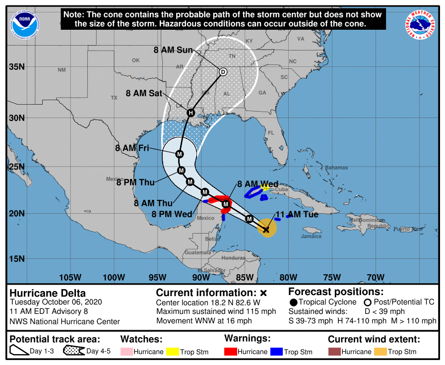
From the National Hurricane Center, 10 a.m. update Tuesday, Oct. 6.
Satellite imagery and recent NOAA Hurricane Hunter aircraft data show that Delta is a very symmetric and compact hurricane. The aircraft reported a tiny 5-nmi-wide eye, which has also been seen in radar imagery from the Cayman Islands, and there is a hint of a pinhole eye in infrared satellite data.
Delta has continued to rapidly strengthen over the past 24 hours, with an estimated 55-kt increase in wind speed between 1200 UTC Monday and 1200 UTC today. Environmental conditions of low vertical wind shear, deep warm waters, and sufficient mid-level moisture are expected to support additional rapid intensification through today, and the only reason that the strengthening could slow is if a difficult-to-predict eyewall replace cycle begins.
Given that, the NHC intensity forecast is above the various intensity aids and call for Delta to be an extremely dangerous category 4 hurricane when it nears the Yucatan. It could be stronger than indicated below since landfall is predicted to occur between the 12 and 24 h forecast points. Some reduction in intensity is likely when Delta moves over land, but the environmental conditions over the southern Gulf of Mexico are expected to support re-strengthening, and the NHC intensity forecast shows a second peak in 48-72 hours. As mentioned before, increasing southwesterly shear and cooler shelf waters near the northern Gulf coast are expected to cause some reduction in wind speed, but Delta is still expected to be a dangerous hurricane when it nears the northern Gulf coast.
Delta is moving west-northwestward at about 14 kt. A mid-level ridge that extends westward across Florida and the northeastern Gulf of Mexico should continue to steer Delta west-northwestward to northwestward during the next couple of days. As the hurricane nears the western portion of the ridge it should slow down. By day three a developing trough over the south-central United States is expected to cause Delta to turn northward toward the northern Gulf coast. The track guidance is tightly clustered through 48 hours, but there is still a fair amount of spread thereafter regarding the timing and details of the northward turn. The ECMWF and its ensemble mean are well west of the bulk of the remainder of the guidance. The NHC track lies near the TVCA multi-model consensus which is close to a blend of the GFS, HWRF, UKMET ensemble mean.
NHC 10a