

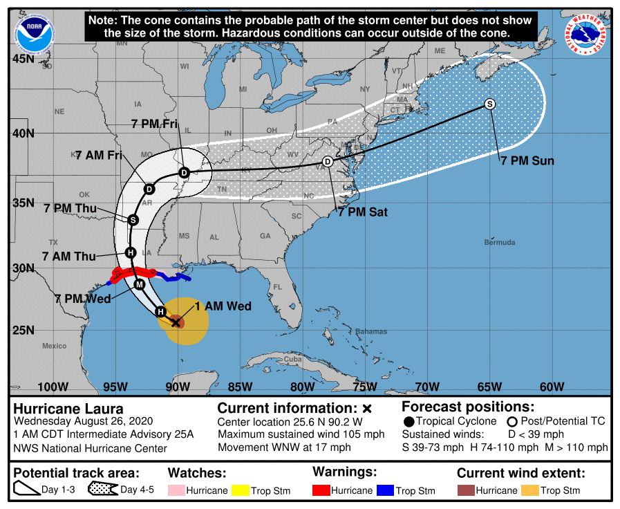
At 100 AM CDT (0600 UTC), the center of Hurricane Laura was located near latitude 25.6 North, longitude 90.2 West. Laura is moving toward the west-northwest near 17 mph (28 km/h), and this general motion should continue overnight. A turn toward the northwest is forecast later today, and a northwestward to north-northwestward motion should continue through Wednesday night. On the forecast track, Laura should approach the Upper Texas and southwest Louisiana coasts on Wednesday evening and move inland near those areas Wednesday night or Thursday morning.
Laura's cloud pattern is becoming better organized on satellite images, with a banding feature over the eastern portion of the circulation and an expanding central dense overcast with cloud tops of -80C or colder. The upper-level outflow is becoming better established over the northwestern quadrant. Flight-level and SFMR-observed surface winds from NOAA and Air Force Hurricane Hunter aircraft indicate that the maximum winds have increased to near 80 kt, and the central pressure is falling. The hurricane is expected to remain over SSTs near 30 deg C until it nears the coast, with only moderate vertical shear. The SHIPS Rapid Intensification Index shows a significant probability for a 25-30 kt increase in strength during the next 24 hours, and this is reflected in the official forecast. This is also between the simple and corrected intensity model consensus predictions. Laura will weaken rapidly after landfall, but it will likely bring hurricane-force winds well inland over extreme western Louisiana and eastern Texas.
Laura