

From the National Hurricane Center • Sunday, Sept. 20, 4 p.m.
After a short-lived intense burst of deep convection a couple of hours ago, which helped to spin up a mid-level eye feature in radar imagery, Beta's convection has waned somewhat and the eye feature has become less distinct.
There is no significant change to the previous forecast track or reasoning. Beta is expected to remain within weak steering currents for the next couple of days, caught between a mid-level ridge over Florida and a weaker ridge located over the U.S. Southern Plains. Thereafter, the ridge over Florida become the dominant steering feature by amplifying northward and northwestward across the southeastern U.S. by early Tuesday, nudging Beta northward by late Tuesday, then followed by a faster northeastward motion on Wednesday through Friday. Due to the continued southwest to westerly shear expected to affect the cyclone, which will keep the convection and associated best pressure falls confined to the northeastern and eastern quadrants or near the Texas coast. As the result, the new NHC forecast track lies near the previous advisory track, and it located along the right side of the track guidance envelope, but not as far right as the new GFS-ECMWF (GFEX) consensus model. which keeps Beta over water for the next several days.
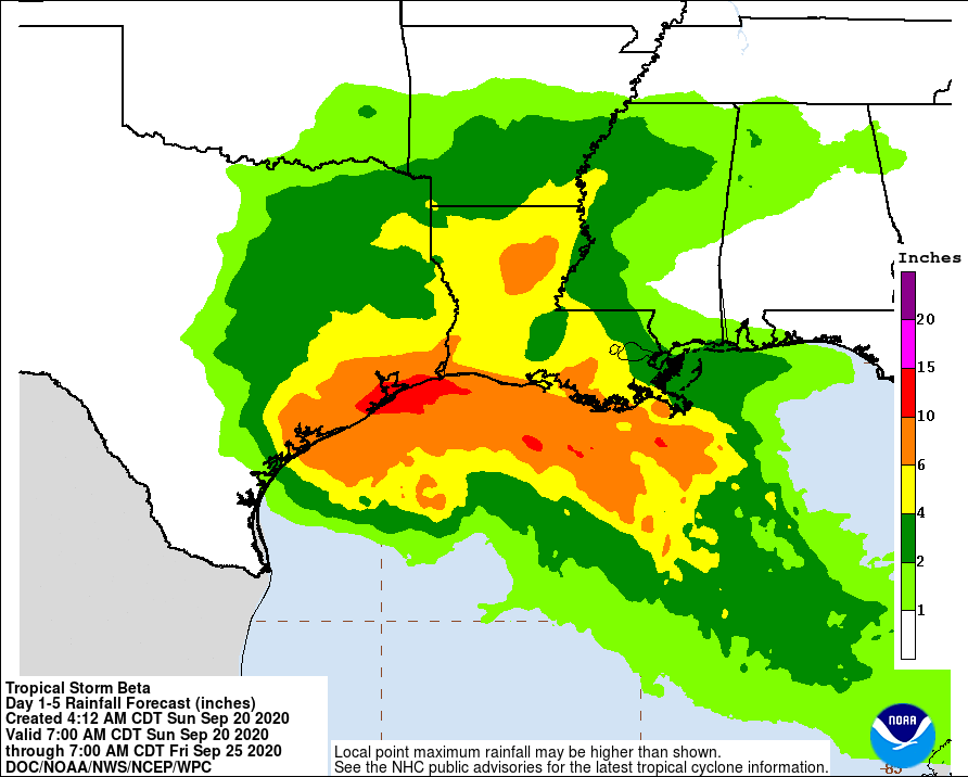
1. The expected slow motion of Beta will produce a long duration rainfall event from the middle Texas coast to southern Louisiana. Flash, urban, and river flooding is likely. Rainfall will also spread northward into the ArkLaTex region and east into the Lower Mississippi Valley where flash, urban, and river flooding is possible.
2. There is the danger of life-threatening storm surge near times of high tide through Tuesday along portions of the Texas and Louisiana coasts within the storm surge warning areas. Residents in these areas should follow advice given by local officials.
3. Tropical-storm-force winds are occurring along portions of the northwestern Gulf Coast within the tropical storm warning area in Louisiana. These winds will spread westward to the Texas coast later today and Monday.
Beta